
600 Million Years of Cynon Valley
Geological History
4. The Post-Carboniferous History of the Cynon Valley
4.1 The Permian and Triassic Periods
Nothing is permanent on the surface of the Earth and the conditions that gave rise to the luxuriant forests were soon replaced by those of a vast, hot, arid red desert within Pangea and the period known as the Permian had began. The time travelling resident would see a more familiar sky at night at this time since the Valley was now 30 degrees north of the equator as can be seen on Scotese's Late Permian (255Ma) map. (Figure 24)
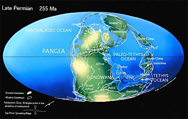
Figure 24. The Late Permian World. The outline of the British Isles
is marked to the north of the Central
Pangean Mountains at a latitude of 30 degrees north of the equator, a
latitude where the Sahara Desert
exists at the present time. The location of the Cynon Valley can be detected
as land though to the north-
east a large inland sea, referred to by geologists as the Zechstein Sea,
stretched from the north-east of
England to central Europe. Note that Gondwana still exists as a single
continent but there is a complete
absence of ice sheets in polar regions at this time. This was "hot house" Earth.
(http://www.scotese.com/newpage5.htm)
The end Permian (251.9 million years ago) was the time of the greatest extinction of life that the Earth has ever experienced, far greater than that which wiped out the dinosaurs. During it, 96% of all marine species and 70% of terrestrial vertebrates were wiped out and all those lush Carboniferous forests disappeared from the face of the Earth. It was a rapid (almost instantaneous in geological terms) extinction with no prior signs and, although many theories have been presented as to its cause, no universally accepted single cause has yet been discovered. However there is strong support for the proposal that the extrusion of vast, thick volcanic deposits of this age, known as the Deccan Traps, in India had a major impact on the Earth at that time and were the primary factor that gave rise to a succession of events that caused the extinctions. This was the time of a very hot Earth with the atmosphere some 6 degrees centigrade above current temperatures. All the Gondwana ice sheets had melted and the Earth now entered what is known as a “Hot House Earth” where no ice sheets exist, a situation that prevailed on Earth until the Miocene epoch, 14 million years ago. The Permian period was not a comfortable time for our time traveller to be on the land where the Cynon Valley would develop.
On a large scale, Pangea was already starting to break up and the early stages in the formation of the Atlantic Ocean were happening. Very early fractures with associated deep sea volcanoes and metal-carrying hydrothermal vents known as black smokers, similar to those found today on the floor of the Red Sea, have been identified in some of the lead and zinc mines in Ireland as having formed on the Carboniferous sea bed. The same forces that caused these deep seated fractures in Ireland caused the large crustal block on which the Cynon Valley sits to be uplifted, because of its buoyancy relative to the denser underlying rocks, with a tilt gently to the south east and with the attendant fracturing of the brittle rocks. All of that original surface has now been eroded away.
Until the deposits from the ice sheets less than a million years ago no rocks are present in the Cynon Valley to give a record of those 250 million years following the upheaval caused by the formation of the mountain chain to the south and the amalgamation of the continents. During those 250 million years the supercontinent of Pangea completely broke up, the Atlantic Ocean was formed, a vast ocean known as Tethys and Paleao-Tethys developed and closed forming the chain of mountains from Morocco through the Alps, the Middle East, the Himalayas and south east Asia to Indonesia. The initial stages of this process can be seen on Scotese's Early Triassic map which shows the outline of the British Isles and Europe. (Figure 25)
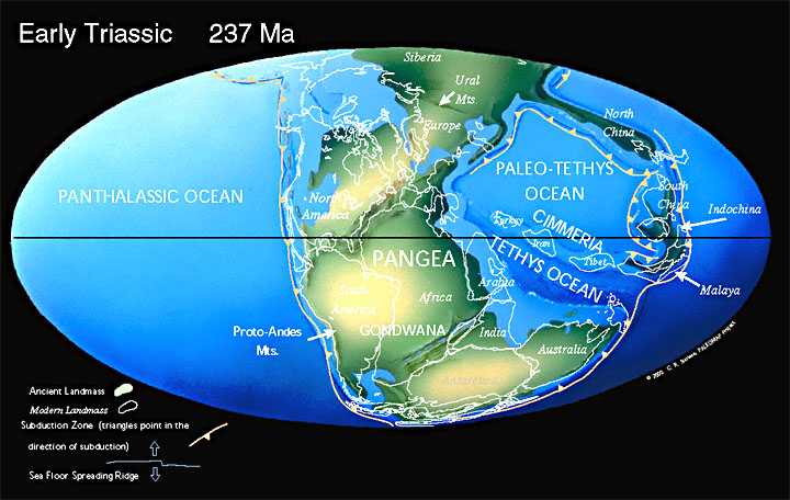
Figure 25. The Early Triassic world. Note that the British Isles are in latitudes where desert conditions exist
(http://www.scotese.com/newpage8.htm)
During the Triassic life recovered from the effects of the mass extinction and populations exploded in number but left no trace of any of this in the area of the Cynon Valley. The evolution of continents and oceans can be followed on the Permian to Miocene maps, and it will be noted that the British Isles and particularly that part on which the Cynon Valley rests is in a passive location for this length of time with little more happening to it than a slow transport northwards with some periods of block uplift or subsidence. The now deeply buried Avalonia continued to behave as a stable block and protected all the rocks that had formed on it from severe deformation.
4.2 The Cynon Valley starts to be formed (Triassic to Early Tertiary)
A question that has been asked for a long time is when did the valleys of the South Wales Coalfield first form? Evidence to support the suggestion that they were initiated on the south easterly slope initiated by those forces active during the early stages of the break-up of Pangea comes from across the Bristol Channel in the Mendip Hills. Here small valleys, which have all the characteristics of desert wadis with coarse, locally derived, deposits, formed during the Triassic period some 230 million years ago, occur. They appear to have been excavated during the desert period following the formation of Pangea and similar rocks of the same age have been identified at Taff's Well where a gorge cuts through Carboniferous Limestone. It is generally accepted that the Mendip Hills now represent an exhumed landscape not too different morphologically from that which existed there some 230 million years ago, namely low rounded hills in a desert. There is adequate evidence, to propose that the valleys of South Wales originated between 280 and 230 million years ago also in that same desert environment.
On barren rock, flowing surface water will exploit any weaknesses in those rocks, such as broken and shattered rocks along fault lines, to form its channel. Since the orientation of the Cynon Valley, and those valleys to the east, follow the NW-SE faults there is clearly a connection between them. Generally it could be expected that early water courses on a newly exposed land surface would follow the slope of the land surface, which was towards the south east, and exploit any lines where the rocks are weaker, namely those NW-SE fault lines. Under the stress conditions described it is highly likely that the faults developed through pulsed movements which resulted in minor scarp features on the surface as can be commonly observed at the present time in areas of recent crustal movements (Figure 26 ). These minor scarps could well have diverted surface water flow along their lengths and hence become the embryonic streams of the current major valley rivers.
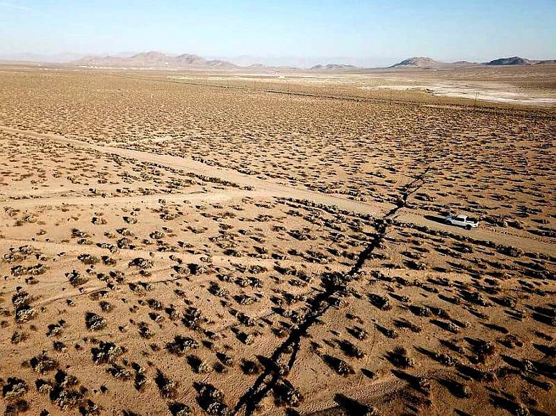
Figure 26. A recent earthquake induced fault in the Nevada Desert.
Newly formed rocks in a desert have no soil cover and no vegetation to protect them against erosion. Hence, the effect of dramatic desert storms with large quantities of rain deposited in short periods of time with flash floods would have been great. Hot desert conditions lasted in this area for about 85 million years until 195 million years ago, but within it was an interval 232 million years ago when the climate changed dramatically, for a 1.2 million year period, to one which was humid with much rainfall. This change in climate may have been associated with major volcanic eruptions (and it did cause global extinctions) but at its end the dinosaurs diversified explosively and began their rule of 165 million years on earth. As regards the Cynon Valley, it is the increased rainfall that is significant because that could have been the event that secured the course of the valley with more persistent erosion of channels that were earlier initiated by flash floods along the fault lines, which were probably minor topographic features then. These early river courses were not the major features that they are today but merely small channels on a gently sloping low lying surface. Early dinosaurs may well have even wandered around the proto-Cynon Valley at that time because dinosaur foot-prints have been found not too far away at Hays Point near Barry.
The conditions continued to change because by 195 million years ago the Cynon Valley locality was about 40 degrees north of the equator where the climate was one of humid monsoon drenched summers and the area most likely would have been covered in ferns and trees (Figure 27).
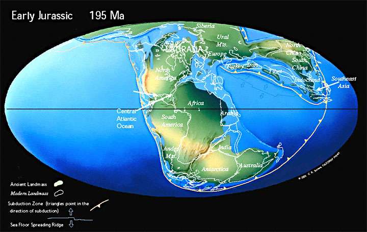
Figure 27. The Early Jurassic World. Note that the British Isles is shown
as small islands for much of Scotland,
Ireland and mid Wales with the rest covered
by a shelf sea. Rocks formed at this time can be seen along the
Glamorgan coast
especially between Ogmore and St. Mary's Well Bay. The Tethys Ocean (not named
on this
map)
is to the southeast of the British Isles where it is opening along
the line of a spreading ridge. Note also
that North America is beginning to
split from Africa. (http://www.scotese.com/jurassic.htm)
Compared to this relatively quiescent environment for the Cynon Valley, the Atlantic Ocean was opening to the west, the North Sea Basin was initiated leading to the formation of the major oil and gas fields and, closer to the valley, a similar but smaller basin was developing along what is now the Bristol Channel. The stable block of rock that hosted the Cynon Valley was likely to have been part of a low island plain with small streams with a shallow sea to the south along the Bristol Channel which was slowly subsiding between major faults along its margins and filling with limestones and mudstones. A little later to the southeast there existed a shallow shelf sea, where the limestones that now form the Cotswolds were laid down, and extended south eastwards into the now widening Tethys Ocean.
Towards the end of this period the new but small Atlantic Ocean had pushed America and Greenland apart and, with a change in the tensional conditions, the block with the Cynon Valley, which had reached a latitude close to that of the present day, started to drift back towards the equator. (Figure 28)
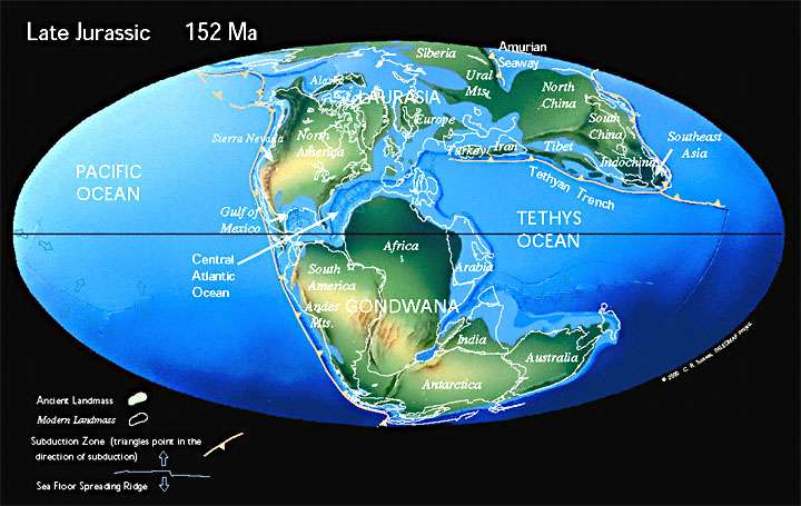
Figure 28. The Late Jurassic World. Note that the Atlantic Ocean was rapidly
opening and that the British Isles
are shown essentially as a single land mass
though as a result of crustal tension major fractures were
developing along
the North sea, the Irish Sea and along the Bristol Channel.
(http://www.scotese.com/newpage8.htm)
By 100 million years ago the new Atlantic Ocean had started to widen rapidly and world sea levels rose dramatically until, by 70 million years ago, there was little land left where Britain now lies and up to 500metres of Chalk were formed in the clear seas that covered the south-east of England. There is clear evidence of the shoreline to the Chalk sea in south Devon which confirms that there were limits to that sea close by. (Figure 29)

Figure 29. The Late Cretaceous World. Note that, apart from south and east
England the British isles are shown as an
island gradually splitting away from
North America. Almost all of Southern Europe is covered by sea
(http://www.scotese.com/cretaceo.htm)
The situation regarding the Cynon Valley for this period is conjectural: it may have been part of an island or completely covered by a sea due to its gentle topography and low altitude. If the conditions were marine anything that had been deposited at this time was probably not very thick and was removed by surface processes soon after the sea retreated and the land rose. When the writer was a student (in pre-plate tectonic days!) and the nature of major sedimentary basins beneath the seas adjacent to the British Isles were poorly understood, the accepted origin of the Rivers of the South Wales Coalfield was on a cover of Chalk which has all now been eroded. Many geological interpretations of the past, where no in situ evidence exists, tend to be contentious, but this writer considers that the early origin of the Cynon Valley in Triassic times fits the whole evidence better than does that of development on a Chalk floor. The area of the Cynon valley has been shown to be land during the Permian to late Cretaceous and it is highly unlikely that there was no rainfall on it and no rivers in existence for a period of time well in excess of 150 million years, only then to be covered by up a great thickness of slow forming Chalk which was then rapidly removed. With the advent of satellite imagery the topography of the entirety of South Wales can be viewed and these images show well rounded smooth hills that are typical of old landscapes not young ones. A good piece of evidence for fairly recent uplift of the land surface over which mature rivers flowed is presented by the River Wye between Monmouth and Chepstow where the meandering river flows through deeply incised gorges with vertical sides. Any half smart school pupil knows that meanders are present in the mature stage of a river where the current is slow moving and deposition of the river's sediment load prevails: not rapid erosion. These meanders must have flowed originally over a low lying flat plain near the sea and maintained their meanders whilst the crust over which the river flowed very slowly rose across its course at a rate no faster than the eroding capability of the river. More dramatic examples of incised meandering gorges can be seen in eastern France where the Jura Mountains rose gradually across the courses of meandering rivers. Slow and gentle uplift of the more buoyant Avalonia and its younger cover as a block over the denser mantle material in response to crustal forces associated with the formation of the Alps and the splitting of the Atlantic Ocean with attendant fault bounded basins along the Bristol Channel and the Irish Sea as well as the North Sea, is most likely to be the main mechanism that caused the tilt of the land which initiated the course of the River Cynon. This is not to deny that the Chalk Sea flowed into the valley bottom (there is no evidence one way or the other) but it is unlikely that the South Wales Valleys were all excavated on a complete cover of Chalk when lower ground in south Devon was a Chalk shoreline.
It is quite likely that our time traveller could have landed many times in the Cynon Valley during these 150 million years and experienced rather pleasant living conditions on each occasion with the exception of the hot-house Permian. Suddenly some 66 million years ago dramatic global events occurred which included a massive meteoric impact and many species on Earth including the dinosaurs becoming extinct, though their descendents may be with us as birds. The shock of that meteoric impact would have been felt in the valley and some of the dust formed of the shattered remains of the meteor and the rock it struck would have eventually settled on the surface of the valley after circling the globe for many years and causing great drops in temperature and loss of sunlight. However these events had apparently no long term effect on the Cynon Valley. The irradiated dust would have been washed away, vegetation would have recovered and animals would have returned, though these would now include many small mammals (Figure 30).

Figure 30. The end Cretaceous World:- The K/T Boundary (K is shorthand for
the Cretaceous and T for the
Tertiary) is one of the major divisions of geological
time. It is a boundary for which there is a clear and well
defined narrow (a
few centimetres at most) band of rock which occurs in the majority of sedimentary
successions
(primarily marine) that were forming at that time. That band contains the radioactive
element
Iridium which is a common element in rocky meteorites such as the one
that hit the Earth near what is now
southern Mexico as marked on the map. (http://www.scotese.com/K/t.htm)
If the Chalk sea had flooded part of the Cynon Valley, it drained rapidly away with the crust tilting to south east as the result of downward draw of the crust by the North Sea basin's sagging due to an influx of sediment. The Cynon Valley, like the rest of western Britain experienced elevation, in some places for hundreds of meters during this period of time transforming them into plateaux or upland plains, due to the combined forces of the opening of the Atlantic Ocean and the sinking of the North Sea basin. This elevation of the land was probably pulsed, thus giving a succession of base levels to which the rivers of Wales eroded and hence underwent a succession of re-juvination features represented by different plateau levels throughout Wales. The area could well have become a more modern looking scene with flowering trees and shrubs and remained more or less like this for almost 60 million years. The remains of this upland plateau can readily be seen on the hill tops above the Cynon valley and others have been recognised on the Cambrian Mountains of mid-Wales. Consequent to the uplift(s), the eroding powers of the early streams would have become enhanced and what had been small streams on a gently sloping plain now started to cut deeper into the bed-rock as part of the process to reach sea level. The latter part of that period, in the order of 26 million years, probably enabled the broad course and shape of the Cynon Valley to be established. Figures 31 and 32 show that the Cynon Valley would be close to its present day global position but it is worth noting that much of southern Europe, and particularly Italy, had yet to form.
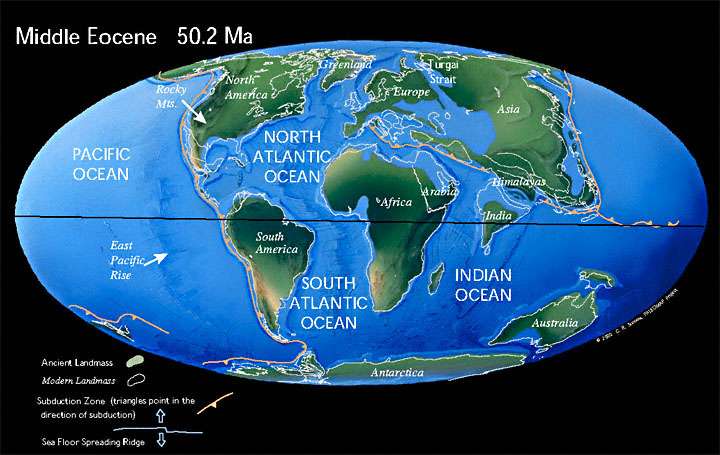
Figure 31. The Middle Eocene World. Note that the British Isles is incorrectly
shown as covered in sea: most of it was land
except for parts of the south coast
of England and a large lacustrine environment existed in the London basin.
(http://www.scotese.com/newpage9.htm)
Our time travelling resident would for the most part of this time be in relatively familiar surroundings as the area drifted gradually northwards to its present position. To the west, the Atlantic Ocean continued to open right next to the British Isles and a large volcanic province developed along the fracture lines associated with this opening. Volcanoes existed all along the line of the Hebrides and vast lava flows occurred in Antrim in a manner similar to modern day Iceland. More than likely our time travelling resident would have felt the effects of these volcanoes frequently but the deep marine gulf with tropical plants and animals that covered the London area would have required a long walk. However, the temperatures may have been a little hot for the individual because higher global temperatures, about 3 degrees centigrade above the present day, existed about 30 million years ago.
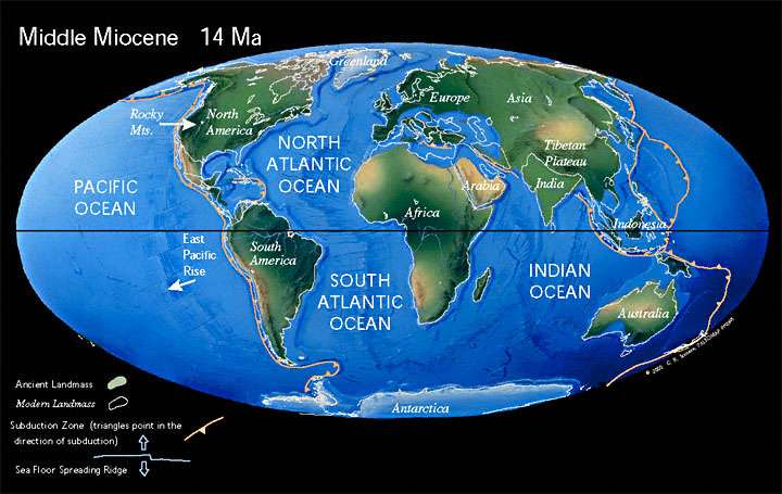
Figure 32. The Middle Miocene World. The British Isles are clearly shown as land and Iceland begins to form. Note that
for the first time since the Upper Carboniferous there is an established ice cap over Antarctica and the beginnings of a
permanent ice cover over Greenland. The world has entered a period as “Ice House Earth”.
Elsewhere in the world much happened during the Miocene (Figure 32). Major oceans opened further, continents moved and some collided with others (India with Asia), mountain chains were formed (Western seaboard of the Americas) and the distribution of continents and oceans that we are familiar today resulted. Other than the opening of the Atlantic Ocean the main event that affected the British Isles and indeed the Cynon Valley was the formation of the Alps. Although only minor in comparison to the forces that produced the Alps themselves those forces left their mark on southern Britain. In south Wales those three major fractures that were initiated some 600 million years ago, the Carreg Cennen, the Swansea Valley and the Vale of Neath Disturbances, were again re-activated as the result of these Alpine movements, and, each under crustal tension, displaced the rocks along them downwards to the north west. These Alpine movements probably contributed to a slow uplift of the block underlying South Wales.
4.3 Later Evolution of the River Cynon
From its probable inception as small streams some 250 million years ago, the course of the River Cynon along with the other rivers of the South Wales Valleys, has had a long time to develop, though its development would certainly have been halted during those periods when marine conditions existed in the vicinity. Clear evidence in regards to the timing of the stages of its development is scarce to say the least and it is easy to fall into the trap of treating conjecture as fact. There is good topographic evidence to substantiate much about its development and a sequence of events but when exactly those events happened cannot be stated with certainty. The account presented below is drawn from discussions in F.J. North (1962) "The River Scenery at the head of the Vale of Neath" Chapter 5,pp67-94. It is well worth reading despite its age and much of the content of its earlier chapters has certainly been superseded by more recent information. It is hard to find later publications which clarify the discussions presented in chapter 5.
By the end of the Miocene the River Cynon had become a large river flowing through one of those rather pleasant valleys described above. It had long since ceased to be a small stream following an ancient fault line but had helped carve the wider valley we recognise today and flowed into the River Taff at Abercynon over that period of maybe 30 to 40 million years. However it does not conform to the classic text book example of a river valley which is narrow and “V” shaped in its higher reaches and broader downstream. The narrowest part of the Cynon Valley is at Mountain Ash, not Hirwaun or at it source in Penderyn, and this is largely due to the nature of the underlying geology with weaker Coal Measure shales outcropping at the north of the valley and the harder Pennant Sandstone reaching valley bottom at Mountain Ash (Figures 20 and 33).
Figure 31 is a highly simplified map but is fit for the purpose of this report. For those who wish to view more detail of the geology of the area, excellent 1:50,000 maps have been produced by the British Geological Survey (BGS) and two sheets are relevant to the Cynon Valley, namely the Merthyr Tydfil sheet (231) for the top of the Valley and the Pont-y-pridd Sheet (248) for the lower part of the valley. Two versions of the geology are available, one including the cover of ice age and recent deposits (Drift edition) and one with the drift removed and showing the underlying solid rock geology (Solid edition). These can be viewed free of charge on line at https://webapps.bgs.ac.uk/data/MapsPortal/. Go via the map portal to Geological maps and then select Geological Maps of England and Wales New series and scroll down the list to sheets 231 Merthyr Tydfil and 248 Pontypridd, and view both drift and solid geology editions. It is possible to focus in to a locality of interest and view that section in detail since there is a great amount of detail on that map and it may take a while to become familiar with what is shown on it with constant cross referencing the rock succession column at the side.
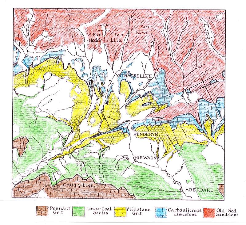
Figure 33. Simplified geological map of the area at the headwaters of the River Cynon, (from
North 1969). The uncoloured areas are the unconsolidated superficial deposits laid down
during the last Ice Age or later. The key to this map uses and old nomenclature for the rock
formations which does not conform in detail with that given on the maps produced by the
BGS. Note the Vale of Neath Fault zone from WSW to ENE which has displaced
the strata and
also the NNW-SSE faults which have a close directional relationship with the
course of many
of the streams.
4.3.1 The ancestral River Cynon
It has often been said that the River Cynon is too small for its valley and in its present state that is a perfectly understandable comment for its erosive power, even in flood, in not high. But the River Cynon was not always as small as it is now and at the head-waters of the ancestral Cynon the situation was quite different. The ancestral Cynon did not rise in Penderyn, though that part of the current river from Hirwaun to its source in Penderyn was a tributary of it. There is good evidence and a consensus of opinion that the Afon Hepste and its tributaries flowing into Afon y Waun, the Afon Mellte and its tributaries Afon Dringarth and Afon Llia, the Afon Nedd Fechan, the Afon Pyrddin and the Afon Sychryd were all previously tributaries of the Cynon. During the Miocene uplift the topography of the region was more subdued than now with the absence of deep incised river channels and the deep valley along the Vale of Neath did not exist as far north east as it does today (Fig. 34).
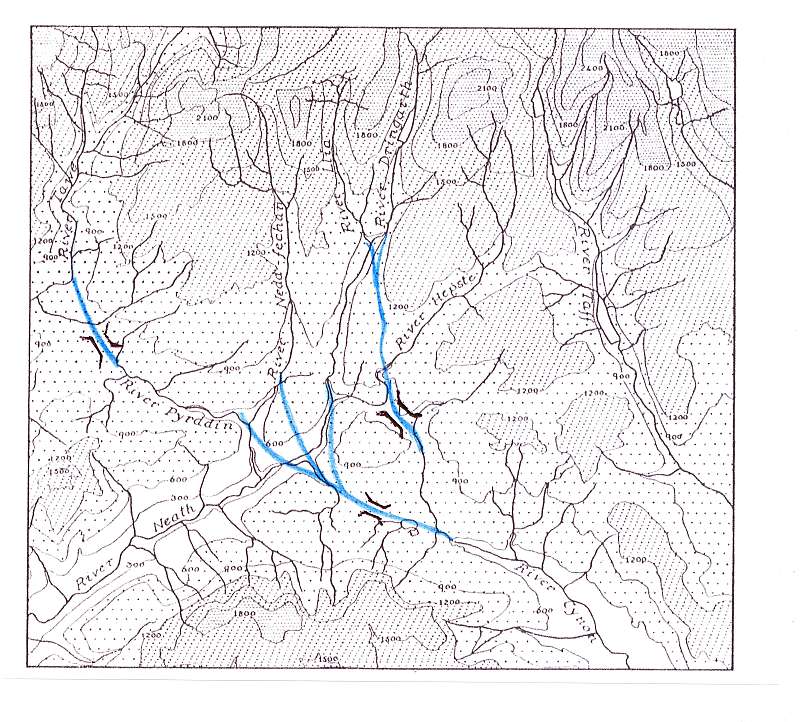
Figure 34. The Ancestral River Cynon and its tributaries. The blue lines show the suggested
course of the original river channels and the wind gaps are indicated as ][. (North 1962)
The same case could be argued for Cwm Tawe and it has also been suggested that the head-waters of the Afon Tawe flowed into the Afon Pyrddin hence increasing the water content of the Cynon substantially (Figure 34). An examination of topographic maps and especially satellite images, as can be found on Google Earth, shows a good alignment of the Pyrddin with the Tawe at Pen-y-Cae in upper Cwm Tawe. From its confluence with the Nedd Fechan there a continuation in the trend of the Pyrddin along the Sychryd to link with the Cynon through the flat and marshy ground by Hirwaun ponds. The road through the industrial estate to the north of the A465 at this position is along a hollow between two small hills which is suggested to be the course of that ancient river and such a feature is known to geologists and geographers alike as a wind gap. Other wind gaps occur in a southeasterly direction from Caer Howell to Ynys-wendraeth, Penderyn (Figure 35) and to the southeast of the Henrhyd Waterfall on the Nant Llech near Coelbren. Wind gaps are common throughout much of south Wales and each represents the abandoned bed of a former river course, the waters of that river having been captured by another river which was eroding more rapidly and crossed its course. The dating of such river capture is not clear but North refers to the capture as having taken place on the uplifted surface during the Tertiary period and before the Ice Ages. There is clear evidence for a pre Ice Age timing for the capture because, as can be seen on both Figure 33 and Figure 34, the former channels and wind gaps are now filled with late glacial sediments.
Figure 35. The wind gap north of Penderyn. The farm on the left is Caerhowell, the one in
the centre is Heol Las and the one on the right is Ynys-wendraeth. Compare this
photograph with the maps, Figures 33 and 34 and it can be seen that the drift
filled
channel which approximately follows the route of the A4059 was the channel of the
combined Afon Llia and Afon Dringarth. The wooded hollow in the top left is the course of
the Afon Hepste. Cwm Cadlan is the open valley to the right beyond Heol Las.
4.3.2 River capture by the Afon Nedd and Afon Tawe
The line of 600 million years ago along Cwm Nedd, and quite likely that along Cwm Tawe also, influenced the process of river capture of the headwaters of the Cynon. The Cynon flows into Afon Taf but the Nedd flows directly into the sea and rivers always ultimately erode to a profile with its base at sea level. Sequential on the pulsed uplift of the land is a relative lowering of sea level. Also, some 20million years ago during the Miocene, ice sheets had stated to develop over Antarctica and also on Greenland which resulted in a locking of vast volumes of water onto the land with a resultant drop in sea level. Uplift and a lowering of sea level combined resulted in enhanced erosion by rivers to their lower sea level base. This process, known as re-juvination of the rivers, with attendant increased rate of erosion, gave rise to the rapid deepening and incision of the river bed, as is clearly seen in the headwaters of the current Afon Nedd. More rapid erosion would be facilitated by the presence of weaknesses in the bed rock as is the case along the Vale of Neath Disturbance. The result was that the Nedd eroded to its lower base line at a much faster rate than did the Cynon to its confluence with Afon Taf at Abercynon.
This increased erosion began with waterfalls at the coast line and these retreated with some degradation up river incising the river bed rapidly. When the retreated incision reached Pontneddfechan, it cut across the line of the Pyrddin -Nedd Fechan and captured the waters in them and their erosive effect was then increased resulting in the incised nature of both those rivers as seen today. With further retreat the waters of the Sychryd and Mellte were captured near Craig y Dinas thus depriving the ancient Cynon of a large proportion of its catchment. Increased erosion then took place along the Afon Mellte with the development of its incised gorge and in due course the capture of the Afon Hepste and its headwaters including those of the Afon Llia and the Afon Dringarth leaving the wind gap near Ynys-wendraeth just to the north of Penderyn (Figure 35). This river capture deprived the Cynon of all its high ground catchment leaving its source as the small stream that issues at Penderyn.
It has also been suggested that a similar process of river capture was taking place along the line of the Swansea Valley Disturbance which captured the ancestral Afon Tawe and its tributaries which had previously flowed into the Afon Pyrddin through the flat wet ground of the wind gap near Coelbren, hence diverting a large volume of water from the Cynon to its own course. The top of the Henrhyd Waterfall on the Nant Llech is likely to be at the original elevation of that river system which formerly flowed into the Cynon via the Afon Pyrddin.
4.4 The Pleistocene Ice Ages
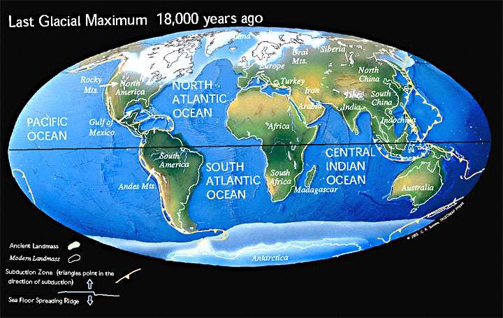
Figure 36. The World during the last Glacial Maximum. This shows the situation
immediately before the last
retreat of the ice from Britain. Note that much
of the continental shelf around the British Isles was land at this time.
(http://www.scotese.com/lastice.htm
The Earth has been in this Ice House Climate for the past 30 million years. Much of the land surface of the Cynon Valley was modified by the dramatic events of the Pleistocene Ice Ages which started some 2,6 million years ago and came to an end (that is, if we are not currently experiencing an inter-glacial period and the Arctic conditions will return) 10,000 years ago (Figure 36).
In Britain it is only in Norfolk and Suffolk that rocks dated as from 2.0 to 2.6 million years are to be found, though thicker successions have been identified in cores from the North Sea. Fossils in some layers of these rocks are of organisms similar to those found today in the Mediterranean whereas others are to be found in the Arctic. This shows that there were fluctuations from temperate to cold climate at this time and the conditions that gave rise to the Ice Age had began. Although details of the events during these 2.6 million years differ across Britain there are generalities that relate to the conditions in the Cynon Valley at that time. Since the start of the Ice age cold polar waters have advanced southwards more than 20 times and ice sheets built up on adjacent land masses. During these advances the Gulf Stream flowed eastwards towards Spain and Britain’s shores were washed by cold polar currents from Greenland and average annual temperature fell to between -6 C and -9C. All the mountain regions became centres of glacier growth and, as Arctic conditions intensified, the glaciers coalesced into something like the present day Greenland ice-cap and ice-sheets spread out over lowland Britain. In the warm inter-glacial periods the average annual temperature reached or even exceeded that of the present day. As the climate warmed the vegetation changed from open grassland to light woodland to luxuriant forests only to change back into northern pine and birch, park tundra and finally ice sheet as temperatures dropped. Over those 2 million years the Cynon Valley experienced all of those conditions, though much of the evidence of earlier glaciations has been obliterated where later ice also advanced.
The earliest glaciations were the most extensive especially the Anglian Glaciation (430,000 to 375,000 bp) which covered all of Britain, except the south from SW England along the south coast to Kent, and the adjacent seas (as far as the 200m depth line to the west). Ice sheets well over 1000metres thick reached as far south as London and certainly covered the Cynon Valley. During a major glaciation the weight of the ice depresses the crust of the earth and also the global sea level is lowered because of the large volume of water trapped in the ice sheets. The glaciers themselves left a layer of boulder clay as they advanced with a large mound, known as a terminal moraine, at their limit. As glaciers melted and retreated it was the glacial melt water that dominated the transport of sediment by a mass of braided rivers. Large areas beyond the original glacier front, and on top of the boulder clay during retreat, were covered by outwash gravels and sands.
Ice sheets did not develop in the Cynon Valley during the later glacial epochs but the land itself was affected by the cold conditions and was probably permanently frozen ground. This ground, of course, thawed during the inter-glacial periods. The Devensian Glaciation (70,000 to10,000 bp) was the last of the glaciations and whilst smaller in extent than the Anglian it did reach as far as south Wales, except for south Pembrokeshire. Ice was present in the Cynon Valley and the hills above, covering or removing, during its advance, much of the evidence related to the earlier glaciations and the inter-glacials. The valley does not display classic text-book features of valley glaciation because it was part of a large sheet as opposed to a glacier confined for a long time within a valley as can be seen in some parts of North Wales, the Scottish Highlands and in the Alps.
Features that are clearly late glacial are the mountain cwms, which are those north facing hollows on the hillsides with a rocky amphitheatre shaped back and a lip of boulder clay at the base. A classic example is Graig-y-Llyn and a good one on Tarren y Bwllfa at the head of Cwmdâr (Figure 37). Several others occur on the north scarp of the Beacons and Carmarthenshire Fans such as below Pen-y-Fan and Llyn-y-Fan Fach. During the late glacial period these hollows retained their winter snow and ice throughout the summer period and as long as the cold temperatures lasted longer than the warmer ones they grew and excavated the hollow. When summer temperature dominated they retreated and eventually disappeared often leaving behind a moraine-dammed lake as at Craig-y-Llyn.
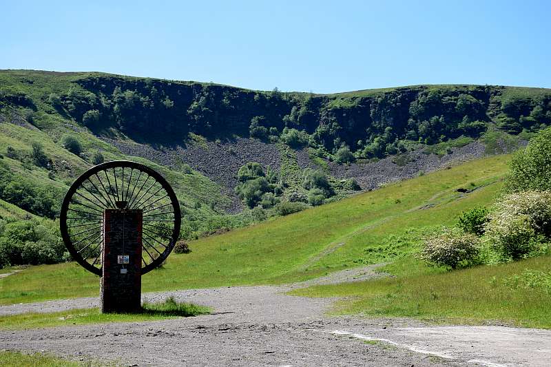
Figure 37. Tarren y Bwllfa at the head of Cwm Dâr from the site of Bwllfa Colliery in the
Cwmdâr Country Park. The source of Afon Dâr is in the wooded area at the foot of the scree.
At the end of the Ice Age the cwm would have held the last vestiges of ice
in the valley.
At the end of the Devensian Glaciation the Cynon Valley ice sheet melted more during the summer period than it grew during the winter and retreated up the valley as is happening to so many glaciers today with an increase in global temperatures. In due course the ice sheet left the valley completely but a share of the melt water from it still flowed down the valley. To appreciate this fully one must imagine the Cynon Valley under sub-Arctic conditions, devoid of vegetation other than for small arctic flora. The rivers would not be raging during the winter but during the spring thaw and summer months greater volumes of water would flow along them from the melting ice.
The fact that the wind gaps are filled with deposits left by glaciers and much of the land to the north of Penderyn is also covered by such material (referred to as "drift" by geologists) supports North's account that the capture of the headwaters of the ancestral Cynon took place long before the last advance of the ice. If the ancestral Cynon had retained all its headwater rivers, with a larger catchment area the waters of which would be increased by great quantities of melt water from melting glaciers, the resulting spring and summer flows down the Cynon Valley would have been torrential, depositing much debris in this process as the flows subsided. However, there is an absence of such material in the valley and no evidence of torrents, and what evidence there is, indicates that the river flow was not particularly violent. This also adds to the conclusion that river capture was pre-glacial. However, it is likely that some of the gorges at the head of the Vale of Neath would have been enhanced by late and post glacial action. Along the Neath Valley, the bed-rock underlying the glacial deposits near the town of Neath shows evidence of a valley form which lies some 40 metres below the current sea level. This indicates that during the Ice Age the sea level was at least this amount below its present level and the river at that time eroded its base to that lower base level. Later the valley became in-filled with glacial deposits which subsequently have been covered by river deposits during the past 10,000years.
4.5 Post Glacial Events
The Cynon Valley was now approaching a form all of its present residents would recognise and with a warming climate, vegetation and animal life entered the valley and a tranquil environment existed. Early humans discovered it and settled there and this is when the archaeologist continues the tale until those humans found a means of recording their histories and the skills of the historians finally come into play. Human beings have certainly left long lasting marks on the valley, such as all the quarries, opencast coal sites and collieries, the extraction of coal from the latter having lowered the elevation of the land surface by over 20 feet. What other impacts have been made by human beings is superficial and the land will recover as evidenced by the re-growth of trees on the hillside between Cwmbach and Mountain Ash on land that looked like the battlefields of Passchendaele as a result of pollution from the former phurnacite works.
Such has been the impact of human activity on the Earth that geologists have now identified a new geological epoch, The Anthropocene, to represent it. Will our waste tips be a source of interest to future archaeologists who may display some interest in the durability of plastic or will they be dismayed by our actions? Or will the ice sheets return and remove most evidence of human action from the surface of the valley and present a strange problem as to how the colliery workings were formed? Time alone will tell but if humans are in the valley when the Arctic conditions return they will find that global cooling will be much more of a problem than global warming. Strange as it may seem today, in the 1970s the pundits of the Club of Rome were predicting a global exhaustion of coal, oil and gas reserves, and the depletion of most minerals by the turn of the millennium and frightened people into the fears of a cold old age. It is well to consider, in view of the whole range of changes that our old valley has experienced, what makes God laugh. People who make predictions !
Cynon Valley History Society is a Registered Charity. Charity No. 510143.
All information © Cynon Valley History Society