
600 Million Years of Cynon Valley
Geological History
3. Creation of the rocks visible in the Cynon Valley: The Carboniferous Period
3.1 The Carboniferous Limestone
About 350 million years ago the situation described above was about to change and the events that took place then eventually brought people to the Cynon Valley. The land had been gradually subsiding combined with a rise in sea level and the area that was once arid coastal flats became covered by a warm clear shelf sea (Figure 9) under conditions similar to the current Bahamas bank with southern Britain lying across the equator (Figure 10).

Figure 9. Cane Bay Beach, Caribbean showing conditions similar to those
under which
much of the Carboniferous Limestone was formed.
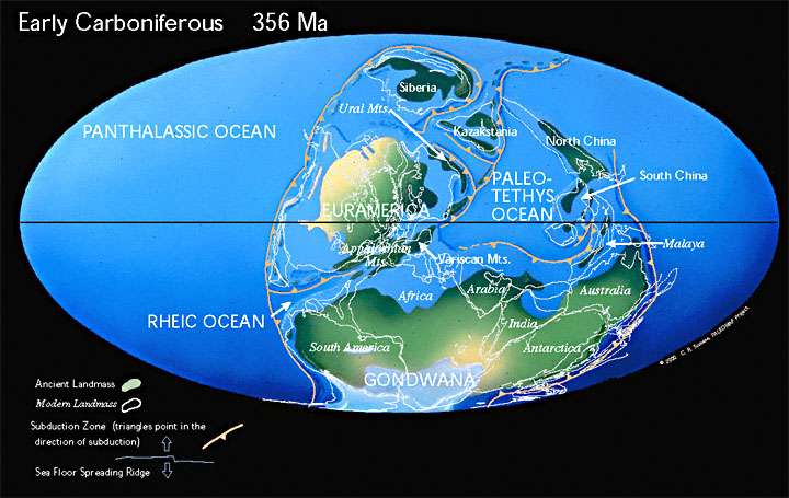
Figure 10. The Early Carboniferous World. An outline of the British
Isles with the southern British Isles
and most of Ireland submerged beneath the shallow sea between the continent
of Euramerica and the Variscan Mountains to the southeast. This can be
found below
the second "R" in Euramerica. Note that Scotland is shown as part of
the mountainous area but
much of South Wales was covered by sea though a large island existed
across Mid and
NW Wales. This level of detail is beyond the scale of the map.
(http://www.scotese.com/newpage4.htm)
Very little land-derived debris was transported into this sea at that time and the lime rich waters precipitated pure lime muds on the sea bed over millions of years in a manner similar to that of lime being precipitated on the inside of kettles. These lime muds eventually became the Carboniferous Limestone that now outcrops at Penderyn (Figure 11) and occurs at depth below the rest of the Cynon Valley. Whilst extracted today primarily for road stone and concrete these rocks have also been used in the Penderyn area as a good building stone, as at the gate to St. Cynog’s Church, Penderyn (Figure 12), and they provided the essential flux for the extraction of iron in the furnaces of south Wales.
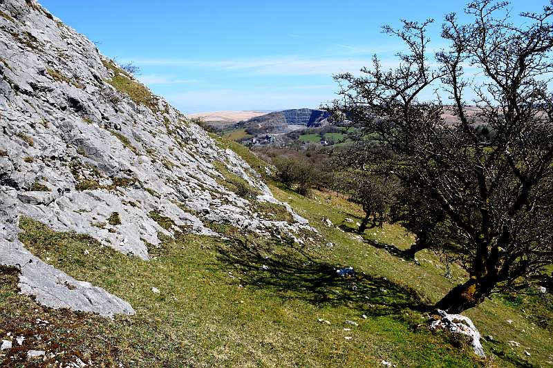
Figure 11. An exposure of Carboniferous Limestone on Moel Penderyn with the large limestone quarry in the distance.

Figure 12. Dressed blocks of Carboniferous Limestone at the gate to St. Cynog’s Church
3.2 The Millstone Grit
Earth movements, that were happening to the south and acting to close the Rheic Ocean, ultimately restricted these seas and shore-line conditions prevailed across south Wales with the accumulation of pure white silica sands over much of the area with some mud deposition in thin bands associated with periodic higher sea levels (Figure 13).

Figure 13. Whitehaven Beach, Queensland Australia, showing a pure white
silica sand beach
similar to those on which the Millstone Grit was deposited.
The pure sands became the Millstone Grit (Figures 14 and 15)which also provided a good building stone at the head of the Valley especially for dry stone walls around Penderyn (Figure 16) , and, more importantly, was the source material for the silica bricks essential for the construction of durable furnaces for the extraction of iron. The remains of silica sand workings can be found on the Afon Nedd Fechan and on the Afon Hepste.
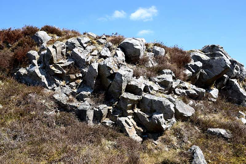
Figure 14. An exposure of Millstone Grit on the flank of Moel Penderyn.
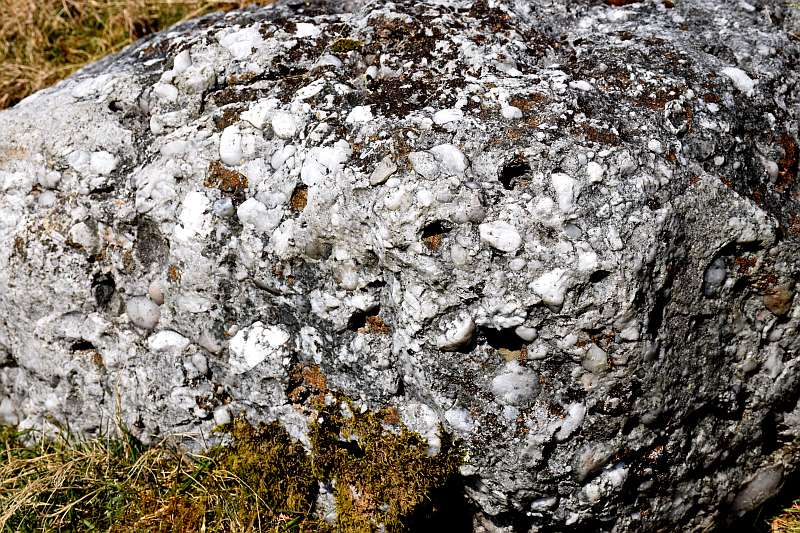
Figure 15. A bed of quartz pebbles within the Millstone Grit indicating
the presence of a
pebble beach within the silica sand.
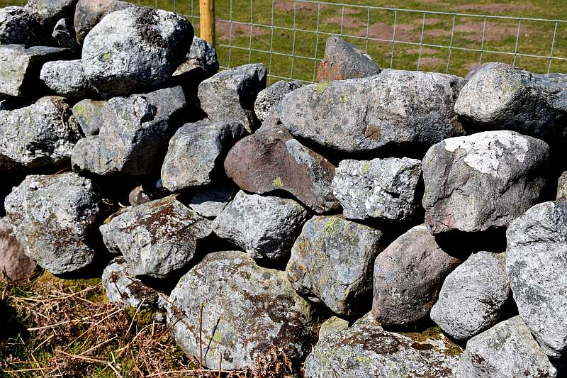
Figure 16. A dry stone wall composed of a variety of rounded boulders
of Millstone Grit at
Penderyn. Note the red/brown boulder of Old Red Sandstone in the middle.
3.3 The Late Carboniferous
3.3.1 The early sedimentary basins
Over time the marine basins noted above were filled with sediment and became vast swamps and mudflats with brackish lagoons almost at sea level and were threaded by slow moving wandering streams. The Rheic Ocean had now closed completely and a supercontinent, called Pangea by geologists, was forming. See Late Carboniferous Map (Figure 17).
Those readers who are familiar with coal mining in the UK will know that each of the major coalfields has its own characteristics and there are even variations across the South Wales coalfield. This is because each coalfield was formed in its own individual basin bordered by land masses that existed at the time of formation. There is no correlation of seams from one coalfield to another but chronological lines can be produced by thin beds of mudstone with marine fossils in them and known as Marine Bands. These are few in number and indicate that there were short lived marine transgressions across the swamps. It is only in the coalfields of Scotland and Northern England that true and sustained marine conditions occurred as indicated by the presence of Limestones in the succession. These indicate that there were some basins that periodically were open to the sea for periods long enough for limestones to form: others including South Wales were not. In detail Figure 17 does not indicate this and neither does it show that there were many fault bounded basins resulting from crustal tension as the result of the incipient break-up of Pangea. The absence of Marine horizons above most of the coal seams dispels the grossly over-simplified scenario often fed to school pupils of marine incursions over the swamps killing the vegetation, burying it and, in due course, it became coal. The reality is far more complex.
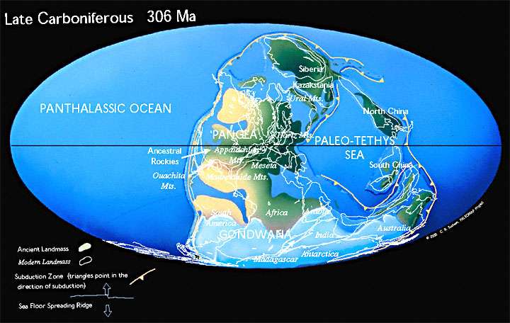
Figure 17. The Late Carboniferous World: the time during which the rocks
of the South
Wales Coalfield were formed. Avalonia was by now completely buried, and
the Caledonide
mountain range had become part of Pangea, situated just to the north
of the Equator and at
a great distance from the Oceans. Note also that the present day southern
continents at this
time formed Gondwana centred around the South Pole and were covered by
ice. As remote
as it may seem, this ice sheet had a bearing on the evolution of the
rocks of the Cynon Valley.
(http://www.scotese.com/late.htm).
3.3.2 The Ironstones
It was in this hot and humid environment that iron within the lagoons became concentrated into large nodules in the form of a mineral called siderite which provided an easily extracted material for the pioneering iron industry at the start of the industrial revolution. Because these nodules had been formed within weak mudstone much of the extraction was done by scouring the area with water impounded in dams which when full were broken to allow the erosive power of the floods to release the iron-stones from the host rocks and they were subsequently hand collected and transported to the furnaces. Most of the miners at that time were local Welsh speakers and the words used to describe the process were sgwrfa/sgwrfeydd or rasys. Their word for a dam, argae, is still used by English speaking residents of the area, and even as far as south Herefordshire, for a small dam. This method of mineral extraction was used for metallic mineral extraction in many parts of Britain at that time and it is quite likely that the lead miners of mid Wales (or Derbyshire), or even gold miners because such a method was used in part at the Dolau Cothi gold mines, brought the technique into the Coalfield. The name of this process remains along the north crop of the coalfield, especially Rasau to the north of Tredegar which was extensively scoured. A village by Tredegar is actually called Scwrfa.
3.3.3 The Coal Forming Swamps and Forests
With gradual elevation of the land, or lowering of global sea level, vast stretches of the swamps became drier and developed into ancient soils on which grew dense tropical forests because by now land plants were well established over the surface of the earth. (Figures 18, and 19). Those soils became leached of some elements thus leaving higher percentages of aluminium which resulted in a material that could be made into good heat resistant bricks. Hence, these ancient soils became the fire clays that were used to produce refractory bricks for the construction of kilns. The un-leached muds developed into the mudstones and shales that were used extensively for the production of bricks and pipes throughout the entirety of south Wales.
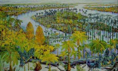
Figure 18. A generalised impression of the environment that gave rise
to coal, namely low-
lying woodland with meandering rivers.
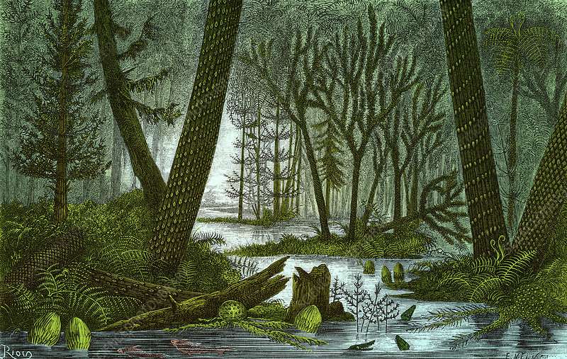
Figure 19. A reconstruction of the conditions that existed in the locality
of the Cynon Valley during
the formation of a coal seam. Note the tree ferns and giant horsetails.
However it was those vast forests themselves that produced the material for which south Wales became famous and indeed drove the population growth of the area, namely coal. There are many clues within the coal as to the nature of those forests and a microscopic examination reveals that it is a highly complex material with a detectable history. As an example, many of the readers of this report who remember the extensive use of domestic coal may recall seeing bands of a fibrous material (called fusain), that looked rather like charcoal, within a lump along which the coal would split easily. That fusain is exactly what it appears to be and was the result of extensive fires within the forest probably initiated by lightning strikes. Fossil plants and animals are found in the strata between the seams and together they indicate that there was a variety of plants, some of which are related to plants that exist today (30 foot horsetails). Invertebrates such as molluscs (in the mud), spiders and dragonflies and vertebrates such as lizards and amphibians, flourished.
The succession of rocks and seams is repetitive thus indicating a cyclicity of conditions starting with the filling in of the shallow arms of the sea to form muds and sands in non-marine conditions, followed by the creation of swamps with the growth of vegetation and the accumulation of peat over a long period of time. A rise in sea level would then cause a rise in the ground water level and a flooding of the peat together with the deposition of fine mud by the overflow of sediment-charged meandering rivers whose outflow to the sea was now impeded by the higher sea level, thus forming a roof to the seams. A lowering of sea level would herald a return to swamp conditions, the growth of vegetation and the start of another cycle.
The formation of the swamp forests and their destruction was in fact a slow and complex process due to rising and falling ground water levels on land related to sea level rise and fall. As the sea rose and the swamps were drowned nearer to the shore line with mud deposited on top of the peat, further inland the water table would start to rise and the swamps migrated landward. With a drop in sea level the migration of swamps would be seaward and desiccation and erosion would remove some of the peats already formed. The cycles are not always complete and there are many cases where a seat earth is not overlain by a coal seam indicating that there was insufficient time within that cycle for a forest and peat to develop. These were the conditions that prevailed for many millions of years on that part of the earth now occupied by the Cynon Valley.
The reasons for the repetitive rise and fall of the sea level during this epoch in earth history can also be seen on the late Carboniferous map (Figure 17). The map clearly shows Pangea and, centred on the south pole, a large landmass (Gondwanaland) covered in ice. Some of that ice melted during warmer interglacial epochs and accumulated during colder period with attendant rises and falls in sea level in the same manner as the sea level rose and fell during the glacial and inter-glacial epochs of the last Ice age. Hence the cyclic sedimentation during the upper Carboniferous and the multiple coal seams that were formed, each with its own characteristics which in turn reflect the history of that seam from the initial composition of the peat.
Because of the extensive Carboniferous age coal seams, formed from vast forests, many people have the misconception that the Carboniferous was a warm period in earth history. The opposite is in fact the case: average earth temperatures were several degrees colder than present day conditions. The vast accumulations of limestones (CaCO3) during the lower Carboniferous sequestrated great quantities of carbon in the form of carbon dioxide (a greenhouse gas) from the atmosphere to combine with calcium in the sea water to form the limestones. Then the tropical forests just took billions and billions of tons of carbon out of the atmosphere through photosynthesis and locked it into the solid earth until man started to extract coal and liberate the carbon once again more than 300 million years later.
Gondwanaland was not devoid of vegetation either and within it developed vast accumulations of peat as in arctic regions today or indeed as in Ireland following the last retreat of the ice. Gondwana experienced repeated glaciations with intervening warmer period which respectively caused the fall and rise in the sea level due to the accumulation of water in the ice caps and later melting. Those bogs also trapped methane (CH4) another greenhouse gas. They in time developed into the coals of Australia, South Africa and India. The use of limestone in the production of cement must not be ignored in this context either because almost half its mass is liberated as carbon dioxide when it is broken down into calcium oxide (quick lime) during the production process. With the development of enormous cities across the world, cement production currently liberates billions of tonnes of carbon dioxide each year.
3.3.4 The Pennant Sandstone
Towards the end of the Coal Measure times major earth movements that closed the Rheic Ocean produced a new mountain chain to the south, the remains of which can be traced from Cornwall to eastern Europe. The swamp conditions of the Coal Measures of south Wales were invaded now by a massive delta composed of poorly sorted sands formed from a large river system flowing northwards from those mountains. This gave rise to the thick sandstone layers of the Pennant Sandstone, a unique rock which does not occur in any other coalfield in the British Isles, which now caps the plateau into which the Cynon Valley has been cut. Because the layers of sandstone are thick (Figure 20) and the fragments within the rock itself poorly sorted, it indicates that the deposition was rapid and not too far from the source rocks, with no time for the water to separate the different rock fragments and minerals that had been derived from the new continent. There were, however, intervals of little or no deposition of sand when layers of mud which became shale were formed. Towards the end of the formation of the Pennant Sandstone, swamp conditions periodically returned to the area and more coal seams were formed.
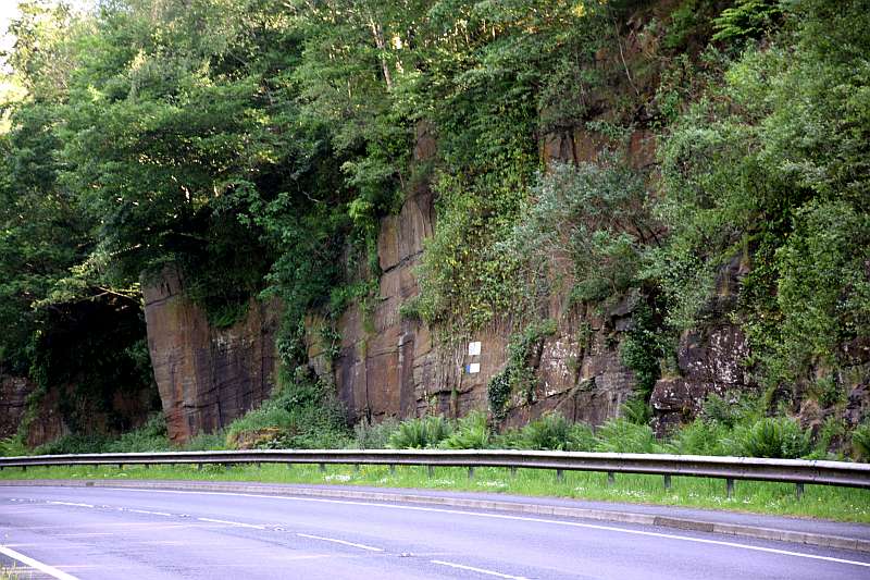
Figure 20. Thickly bedded Pennant Sandstone at Llety Twrner on the A 4059 near Penrhiwceiber.
Without the Pennant Sandstone the valley towns would not have their unique appearance since it has been the major building material for the terrace houses and many commercial buildings (Figures 21 and 22). It is an easy rock to extract and will take dressing by a good stone mason to provide a most attractive facing stone. Most of the prominent buildings such as the churches and chapels and older schools were faced with this stone and fortunately it is being reclaimed for re-use from those buildings which have been demolished. Also, because it was deposited rapidly and poorly sorted with a range of hard and soft components it does not polish well and therefore is highly valued as the wearing surface for roads due to its excellent skid resistance. Whilst the Millstone Grit at Penderyn is a much harder rock and has better strength characteristics, it takes a polish and would not be appropriate for road top dressing.
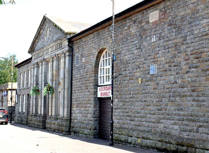
Figure 21. The front wall of Aberdare Market showing well dressed Pennant Sandstone.

Figure 22. Herbert Street Aberdare showing frontage and (now painted)
window sills of
dressed Pennant Sandstone. Note the painted local brickwork around the
doors and
windows typical of Valley streets but the original north Wales’ slate
has been replaced.
Within the existing coalfield and underlying Carboniferous Limestone there is no indication of the proximity of any ancient shoreline to the north of the Carboniferous sea, nor a margin to the Coal Measure swamps nor the Pennant delta fronts. Evidence that these rocks had at one time a greater extent than their current outcrop occurs at Carreg Cennen Castle in the west and on the top of Pen Carreg Calch above Crughywel in the east but the original boundary to the Coalfield is not now determinable. Much has been removed by erosion and the two localities mentioned are where isolated patches of Carboniferous Limestone occur at, in the case of the latter, an elevation some 400 feet lower than what would be expected from a projection to the north of the dip of the beds at the north of the coalfield.
3.3.5 The formation of the South Wales Coalfield
About 280 million years ago during the early Permian period the crust of the British Isles was subjected to strong compressive forces during the main stages of the formation of that large mountain belt to the south, called by geologists the Central Pangean Mountains, and the formation of the super-continent ,Pangea, extending from 60 degrees north of the equator to the south pole, was complete. In the British Isles those forces were strongest in south west England but they did buckle the Old Red Sandstone and the Carboniferous Limestone in the Gower Peninsula and South Pembrokeshire and the Coal Measures around the Aman and Gwendraeth Valleys, with layers of rock tilted to vertical in places. Less intense effects were imposed on the Cynon Valley and the eastern part of the coalfield because of the presence at depth of that ancient continent, Avalonia, which acted as a strong block and prevented intense deformation affecting those rocks lying on it. A broad basin structure (with a gentle large arch shaped structure, known as an anticline, centred on Pont-y-pridd) was formed with a west to east trend (Figure 23). The rocks of the Cynon Valley therefore slope gently to the south with the deepest part of the basin located near Abercynon. A good place to see this feature (best viewed in late winter light which picks out changes of slope better than high summer sun) is from the top of Graig Rhiw Mynach looking south-east across the valley where the gently southward sloping shelves on the valley sides reflect the structure of the underlying Pennant Sandstone. The Pennant Sandstone itself is well displayed in road cuttings at the top of Graig Rhiw Mynach and also on the Rhigos to Treherbert road at Craig y Llyn and at valley bottom level at Llety Twrner on the A4059 at Penrhiwceiber (Figure 20).
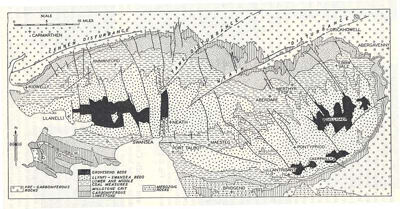
Figure 23. Simplified Geological map of the South Wales Coalfield from
British Regional Geology, South Wales,
British Geological Survey, HMSO, Crown Copyright.
Note the following:
At any one location the map shows the occurrence of the rocks on the surface
with older rocks at depth below and where younger rocks which would have
lain on top have been removed by erosion. Aberdare is situated on the
Lower and Middle Coal Measures which is where most of the productive
coal seams formed. Mountain Ash to Abercynon are built on the Pennant
Sandstones (referred to on the key as Llyfni to Swansea Beds which are
divisions of the Pennant) with the productive coal seams at depth. The
Carreg Cennen, Tawe and Vale of Neath faults are marked only where their
line can be mapped but their extent is greater. The solid N-S lines in
the west and NW-SE lines in the east of the coalfields are a selection
to represent the many faults that cross the coalfield. The number, extent
and magnitude of these many faults have been established primarily from
surveying within the collieries of the coalfield since they cannot generally
be seen below the soil and other surface material over most of the area.
In the east of the coalfield, note that the orientation of the valleys
follows the line of these faults.
When those compressive forced had ceased the rocks were under a state of tension with a general W-E extension which gave rise to major and minor fractures, called faults, and other related fractures with no movement along them known as joints. Those very early lines of weakness, namely the Vale of Neath, Swansea Valley and Gwendraeth Valley Faults were all re-activated along their NE-SW trend by these forces. However, along the northern part of the Coalfield faults trending from the northwest to southeast developed. The amount of vertical movement along these faults ranged from a few feet to tens of feet and the smaller displacements would have been totally unpredictable within a mine without some of the geophysical techniques used today. Those faults caused problems for the miners because a fault with six feet of displacement across a three foot seam would put the seam out of sight. Such faults were a nightmare for the engineers with modern long-wall mining and can cost weeks of lost production.
The faults and joints had a more obvious effect on the harder Pennant Sandstone than on the underlying Coal Measures and are also now good conduits for the passage of water. It is the presence of these joints that made it relatively easy to extract Pennant Sandstone for building stone and in many places large blocks could be removed without imposing the additional stress fractures in them that blasting would cause. Anyone who has climbed a valley side will recall looking up at what appears to be the top, only to find when getting there that it is but a shelf and there is another steeper slope ahead. Repeat this a few times before the plateau is reached. The reason for this is the inter-layering of the thick and harder sandstone bands with thinner layers of shale. The sandstones are permeable with a permeability enhanced by the fractures whereas the shales are impermeable. Those joints have opened in many places to substantial fissures aided in their opening by an unstable slope with large blocks of sandstone resting on water lubricated surfaces of shale. This relationship is why there is often a spring line at the base of the steeper shelf above the shale and it is where many a small stream originates. Unfortunately the shelves were seen by those who did not understand, or who would not listen, as ideal places to put colliery waste. Many of us can never forget nor forgive the devastation caused by that intransigence of colliery officials to the people of Aberfan on the 26th October 1966 where colliery waste had been tipped over well known and mapped springs.
3.3.6 The Nature of the Coals and their Formation from Peat
Whilst burial and earth forces were transforming the sands and mud into the sandstones and mudstones, the peat was also undergoing a transformation into coal. Each seam has its own particular characteristics and it does vary in rank across the coalfield but in any one locality the lower the seam in the succession, the higher the rank. The rank of a coal is based on its content of volatile matter (the lower the percentage of volatile matter the higher the rank) and on its swelling properties. The variation in rank of any seam across the coalfield reflects its history. The highest rank coals occur in the west of the coalfield in the anthracite belt. This is where the deformation was at its greatest and where the depth of burial was also the deepest. Anthracites have a very low volatile matter content, highest carbon content and are non-swelling coals. It is generally accepted that the transformation of peat to coal is caused by heat in the absence of oxygen which are conditions that would be achieved by burial in the crust of the earth and its attendant geothermal gradient. These are conditions that would not be met with the current depth of the coal seams and hence at times during the past 280 million years those rocks must have been buried deeper in the crust than they are today.
Only the lowest seams in the Rhigos area are of anthracite rank in the Cynon Valley with many seams throughout the valley regarded as the next highest rank, dry steam coals. These too have good heat raising properties and low swelling which make them good for closed system combustion. Coals with a higher swelling also exist in the valley but the coals with the best swelling properties (also known as coking coals or, for those who remember coals forming a large congealed mass when burned on an open fire, as binding coal) occur in the eastern valleys and in the Margam area. Those coals were used in gas works to produce coal gas and coke. The coke thus produced, provides the carbon for steel production and the relationship between the steel works at Ebbw Vale, Port Talbot and Llanwern with collieries producing coking coal is not incidental.
3.7 The Valley’s Lost Wealth
This 60 million year period in the history of the Cynon Valley area provided high quality limestones, good quality silica and durable grinding stones, shale for brick and pipe making, fire clay, iron bearing nodules, varieties of coal and associated gas, good building stone and high quality road-stone. The Valley possessed much natural wealth from these 60 million years of its history only to see them exhausted in less than 200 years. This is where a geologist’s expertise ends and it is the province of the historians to narrate the story as to how this natural capital was transformed into useable capital, who produced that wealth and how that wealth disappeared from the Cynon and other valleys. Another interesting avenue to pursue is that of sustainable development and how applicable this current trend, as applied to the developing countries, is to the historical development of the Cynon Valley or indeed the entirety of South Wales. Who were the winners and who were the losers? Where is the legacy?
Cynon Valley History Society is a Registered Charity. Charity No. 510143.
All information © Cynon Valley History Society